
New public space and information centre from burned ruins. Why?
5 Onigam Street Ottawa, Ontario Canada
September 30 2025 approximate time 14:30 EST -4 UTC

© 2025 Robert Julian Agnel, All Rights Reserved.
Why
we remember and recognize history
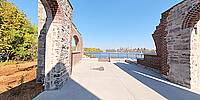
Built in 1899 the former Hintonburg Pumping Station is located on the south shore of the Ottawa River above the Chaudiere Falls. The facility provided water to the Hintonburg neighbourhood of Ottawa from 1899 until the new Lemieux Island Water Purification Plant opened in 1932.
The repurposed ruins on the site were designed to enhance public amenities and facilities and to restore areas of natural vegetation along the shoreline. The site is located at 5 Onigam Street between the Ottawa River Parkway and the access bridge to Lemieux Island. The City owned heritage building was destroyed by fire in 1989 and was in ruins. The new site opened on October 02, 2025. Accessible from the Kichi Zībī Mīkan Parkway and multiuse pathways, the pump house public space complements other civic experiences including the Chief William Commanda Bridge a multi-use pathway crossing the Ottawa River, the nearby Bayview Innovation Centre and the renewed Laroche Park.
Located just north of the Kichi Zībī Mīkan Parkway, the "Great River Road" in the Algonquin Anishinaabemowin language. The Sir John A. Macdonald Parkway was renamed to Kichi Zībī Mīkan Parkway on September 29, 2023. The day before the National Day for Truth and Reconciliation and Orange Shirt Day in response to the legacy of residential schools and the lost children.
This installation will acknowledge the Algonquin Nation and their profound connection to the Ottawa River. This site is located on Unceded Algonquin Anishinaabe territory. The traditional lands of the Algonquin Anishinaabe people, encompassing the Ottawa Valley, eastern Ontario and west Québec and have never been surrendered to the Crown through treaty.
Insta360 one inch, Affinity Photo, Manfrotto tripod
The term "unceded" signifies that no treaty exists where the Algonquin people formally gave up their land rights, meaning their title to the territory continues to exist. This territory includes the city of Ottawa, eastern Ontario and western Québec. Home to the Algonquin people, who have lived and cared for this land since creation. It remains their ancestral homeland and a territory with inherent land and territory rights.
Key aspects of unceded Algonquin Anishinaabe territory:
- Traditional Homelands: The territory is the ancestral homeland of the Algonquin people, who have inhabited it for millennia and have a deep, reciprocal relationship with the land.
- Unceded Status: The land was never fully or legally ceded through a treaty with the Crown, distinguishing it from many other areas in Ontario and the Prairies that have land-sharing treaties.
- Geographic Extent: It includes the Ottawa Valley, straddling the border between present-day Ontario and Quebec.
- Contemporary Significance: The term is often used in land acknowledgments by institutions and individuals in the region, such as Algonquin College and the City of Ottawa, recognizing the inherent rights of the Algonquin people to the land.
- Carriers of the Land: The Algonquin people view themselves as caretakers of the land, a responsibility that has never been relinquished.
Algonquin and Anishinaabeg refer to the same group of Indigenous peoples: the Algonquin are one of the historically significant nations within the larger Anishinaabeg cultural group, which also includes peoples like the Ojibwe, Odawa, and Potawatomi.
The term Anishinaabeg translates to "real people" in their Algonquian language, which is the name of their cultural and linguistic family. The Anishinaabeg have traditionally lived in the Great Lakes region and have a rich history of hunting, fishing, and living in harmony with nature, though their way of life has been impacted by colonization and the impacts of diseases and warfare.
 Tap or click the zoom icon in the bottom right corner of the picture to switch between in-page and fullscreen view