
Trying to Keep Up
The Water Gate, Worcester, Worcestershire, England, UK
December 22, 2024, 11:16 UTC (11:16 local time)

© 2024 Robert Bilsland, All Rights Reserved.
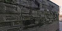
It's been 8 years, 2 months and 29 days since I stood on this very spot to shoot my previous panorama (A Wall of Numbers and History) on the theme of "Numbers". In this time of ever changing climate, to re-visit here is a stark reminder.
Being truthful, I expected there to have been more marks made since my last visit. In the time since the first panorama here there had been plenty of floods, but upon inspection I could only find one new line marker and that was for a flood on the 28th October 2019. For whatever reason, a particularly high flood in 2020 has not been included yet.
Maybe there is some sort of minimum flood height criteria that has to be met before inclusion on the wall? What I do know is that over the last few years Worcester has been hit with more and more floods with the most recent only being a short while ago. Look down and see a layer of sticky mud on the floor.
Lat: 52° 11' 16.261" N
Long: 3° 14' 20.401" W
Precision is: High. Pinpoints the exact spot.
Taken with a Nikon D300 and a Nikkor 10.5mm f/2.8G fisheye lens. Mounted on a Nodal Ninja 5 panorama head and R-D16 rotator atop a Manfrotto 055XPROB tripod. 5 bracketed shots (-2 -1 0 +1 +2) taken at 6 positions 60° apart, tilted 15° down, and another shot taken looking straight up. Raw files then processed in darktable v4.8.1 before being stitched together using PTGui 10.0.19 Pro and converted using Pano2VR 6.1.15 pro.
 Tap or click the zoom icon in the bottom right corner of the picture to switch between in-page and fullscreen view