

Arriving in Village Bay, St Kilda
Islands on the edge, the western-most point in Scotland
4th July 2016, 10:33 BST 09:33U
Loading panorama viewer ...
Configuring ...
© 2016 James Gentles, All Rights Reserved.
Caption
So the theme is numbers, but I couldn't resist sharing my trip to a unique place this quarter...40 miles out in the North Atlantic of the already windswept islands of the Hebrides lies the western extremity of the British Isles - the small collection of islands and stacks called St Kilda. That's 8' 39" west of Greenwich, and less than 6Km from the edge of the UK National Mapping Grid. Yes this is a long way west for us!
The archipelago was inhabited until the 1930s by a people who lived off the land & sea without external help. A people who even before DNA analysis were recognised as being different - hardy souls with feet subtly different, adapted for climbing cliffs to harvest sea-bird eggs. A hard life, made harder when tourism by visiting Victorian Travellers started, they left two things - a temptation of better and the scourge of disease.
The indigenous population all left in the early 1930s, but many left only to live on other remote islands in the Hebrides, to shun the modern world that destroyed their flawed paradise.
When they were evacuated only the indigenous Soay Sheep were left, an un-domesticated prehistoric animal that live on a stack with sheer cliffs and no husbandry.
With this stunning beauty and unique cultural history it is one of the few UNESCO World Heritage Sites that hold both natural and cultural status. With the constantly challenging weather in the North Atlantic, the mystique of this place is simply enhanced by its inaccessibility.
Location
Lat: 57° 48' 8.34" N
Long: 9° 34' 12.91" W
Elevation: 25m
Precision is: High. Pinpoints the exact spot.
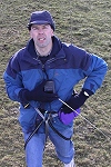
Equipment
4 GoPro HERO2 cameras, with a wooden camera cradle/rig to hold the cameras
in exactly the correct position is triggered by 4
gentWIRE camera
syncronisers. Suspended below a Dan Leigh Cruiser kite with 8ft/2.5m span.This technique produces two hemispheres, and a different workflow in PTGui from the classic ground pano technique. This results in extra effort BUT impossible angles!
See the rig, how Kite Aerial Photography is achieved, and the workflow
 Tap or click the zoom icon in the bottom right corner of the picture to switch between in-page and fullscreen view