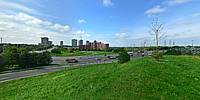
Looking for the convenient spot to make my shot I've noticed this little Hill overlooking whole area.
The name of the nearby park, little winding street and local school is Seneca Hill, and even college (large red building) visible from this spot is named Seneca College. According to the unconfirmed history of this hill it was inhabited a long time ago by one of the clans of the Seneca Nation, an indigenous people. Their name, O-non-dowa-gah, translates as "great hill people", maybe this fact has something to do with the name of this locality.
A few years ago, when the Seneca Hill intersection (crossroad!!??) was reconstructed, earth was for days piled up here, way higher than the surrounding hill. Why, I was wondering?
The official record of the highest peak in Toronto is more than 20 KM away, on the other side of the city and it is listed as 211 meters above the sea. Search for the information about Seneca Hill turned out that little church, some hundred meters away, called The Zion Primitive Methodist Church, was built in 1873 on the "highest" ground in Toronto. On the Google Earth map a small mound in the Seneca Park nearby is marked with 208 M. and spot where I was standing was obviously higher.
A peculiar fact is that by climbing this 20 or so meters from the street I was climbing the highest peak in Toronto, definitely higher than 211 meters above the sea. Now it was finally understandable why all the earth was piled up here during reconstruction, why nice greenery was planted, a path was made: they were making the highest peak in the city!
So it is official: the highest peak in Toronto is now situated 43˚47'45.25" N - 79˚20'33.54" W and its elevation is (lets say) 213.5 M or 700 feet above the sea level. Makes sense?
[Psychography@UrbanSquares.com]
Lat: 43° 47' 45.25" N
Long: 80° 21' 33.54" W
Elevation: 213 1/2 meters
Precision is: Unknown / Undeclared.


 Tap or click the zoom icon in the bottom right corner of the picture to switch between in-page and fullscreen view