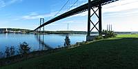
A. Murray MacKay Bridge, Halifax
Halifax, Nova Scotia, Canada
9:50am Atlantic Daylight Time, 22 September 2004
© 2004 Allan Jost, All Rights Reserved.
The A. Murray MacKay bridge between the communities of Halifax and Dartmouth, Nova Scotia was opened on July 10, 1970. It is a four lane suspension bridge with a total length of 1.2 km with a height at centre span of 55 m (181 ft) above the water. The towers have a height of 96 m (315 ft).
There is considerable history around the site of this bridge, which is at the Narrows: a narrowing at the inner end of Halifax Harbour where it opens into the Bedford Basin, a large sheltered body of water approximately 2.5 km. wide x 4.5 km long visible to the left of the bridge beyond the grassy area and parking lot. The Bedford Basin was where many convoys of ships were formed to carry troops and supplies to Europe during the First and Second World Wars. The Narrows (actually somewhat to the right of the bridge) was the site of the Halifax Explosion, where the French munitions ship Mont Blanc collided with another ship, drifted to the Halifax side of the Narrows, and exploded at 9:05 AM on December 6, 1917 completely destroying over 1600 homes and killing almost 2000 people in what was the largest man-made explosion in history before the atomic bomb was dropped on Hiroshima in 1945. A large area in the north end of the city (about 2 sq. km.) was flattened in the blast and many thousands were left homeless.
The panorama was taken from Seaview Park, for about 150 years the location of a small close-knit Black community called Africville, which was unceremoniously uprooted by the city of Halifax in the 1960's to make way, among other things, for the construction of the bridge.
The final point of interest in this pano is the Bedford Institute of Oceanography, located in Dartmouth on the opposite shore just to the left of the bridge.
The panorama was stitched together from 16 images shot in portrait mode using the widest angle setting (equivalent to 35 mm.) on my digital camera. It was my first experience using the PTMac (PanoTools) package.
USA-Canada / Canada-Nova Scotia
Lat: 44° 40' 27" N
Long: 64° 38' 1" W
Precision is: Medium. Nearby, but not to the last decimal.
Canon Powershot G3 @ 7.2 mm (equiv 35 mm), portrait mode, 256 MB CF, Velbon 343E tripod with PH-243 ball head jerry rigged to permit smooth panning with the ball locked. PTMac (PanoTools) software on an Apple iBook.


 Tap or click the zoom icon in the bottom right corner of the picture to switch between in-page and fullscreen view