
Fishin' the Flood
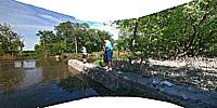
Check Dam on the Sheyenne River North of West Fargo, North Dakota, USA
June 18, 2011, 23:30z (17:30 local)

Loading panorama viewer ...
Configuring ...
© 2011 David Schaubert, All Rights Reserved.
Caption
3 generations of the Schaubert family spending a slow afternoon fishing in the spring-flooded Sheyenne River in North Dakota. It doesn't get much better than this.
Location
Lat: 46° 55' 55.57" N
Long: 97° 56' 31.72" W
Elevation: 300
Precision is: High. Pinpoints the exact spot.
Equipment
Apple iPhone 3GS, Apple Macintosh MacBook Pro 17", PTGui Pro 9, Photoshop CS5 Extended, CubicConverter 2.2.1
 Tap or click the zoom icon in the bottom right corner of the picture to switch between in-page and fullscreen view