
Percieve the height
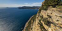
Route des crêtes, Falaise de Cassis, Côte d’Azur, FranceMa
March 16, 2026, 15:19 local time

© 2026 Erik Krause, All Rights Reserved.
Can you perceive the height? Probably not in this panorama. Spherical images may be impressive, but they can’t convey the actual feeling you get when you’re standing 300 meters above sea level at the very edge of a cliff with no railing.
Before the boulders were placed between the edge of the cliff and the road, people used to drive their cars off the cliff. The rusted wrecks can still be seen at the foot of the cliff, though not in this panorama.
When I pioneered the technique of capturing spherical panoramas using a vertical pole 24 years ago, it was breathtaking in its own right: Welcome to Verdon. Nowadays we have drones and spherical cameras that make taking such shots a breeze.
Lat: 43° 11' 25.502" N
Long: 5° 33' 21.002" E
Precision is: High. Pinpoints the exact spot.
Monopod, Sony a7R4, Samyang 12mm fisheye, PTGui pro, Photoshop
Shooting this way is still a challenge, but this time I didn't hold my child over the cliff, like in the Verdon panorama. This same child, now a young adult, pressed the shutter button on his phone, while I tried to hold the camera on the monopod in the same place for all shots. I was also secured with my climbing harness and a rope. However, the bolt to which I was tied vanished into the parallax. Only the camera shadow is visible.
Thanks to Viewpoint Correction and Zero Overlap blending, stitching was much easier and faster than 24 years ago, when it took me 3 days to finish the panorama in a very early PTGui Version.
 Tap or click the zoom icon in the bottom right corner of the picture to switch between in-page and fullscreen view