

© 2024 Pat Rooney, All Rights Reserved.
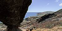
Twenty years after my first WWP submission for 'Bridges' I returned to see what changed from underneath Koko Crater's prominent arch on the southeast tip of O'ahu. See the 2004 pano here.
The islands have been in a dry spell and it shows. Vegetation, particularly invasive trees, have spread and grown tall, but are dry as kindling now. Tiny bits of the arch itself have broken away. Some large boulders haven't moved, while others have split or slid into the gorge below. Some hanging shelves are now cleaved, revealing more ocean view. But the sky and ocean seem just the same. Canon's mid-range sensors have come a long way. I'm using a camera 20 years more advanced — with over twice the resolution, you can zoom in a better outline of the neighboring islands.
Lat: 21° 16' 53.568" N
Long: 158° 41' 55.33" W
Precision is: High. Pinpoints the exact spot.
Canon R7, Sigma 8mm, NN6, LR, PTGui.
 Tap or click the zoom icon in the bottom right corner of the picture to switch between in-page and fullscreen view