
Panamint Valley and Panamint Range, Death Valley National Park, USA (2011)
Panamint Valley, Death Valley National Park, California, USA
December 29th, 2011

© 2024 Brian Richards, All Rights Reserved.
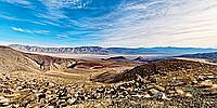
I love the colours and feel of this image, taken as we entered the Death Valley National Park in 2011. This is the Panamint Valley and to the left the end of the Rainbow Canyon, viewed from near the Father Crowley Overlook. The Valley is a long basin located east of the Argus and Slate ranges, and west of the Panamint Range in the northeastern reach of the Mojave Desert, in eastern California, United States. The northern end of the valley is in Death Valley National Park and Inyo County, California. The valley lies in a north–south direction, and stretches from the Panamint Dunes in the north to the Naval Air Weapons Station China Lake in San Bernardino County in the south. The valley is approximately 65 miles (105 km) in length, and is more than 10 miles (16 km) wide in the Hall Canyon area.
See the full Virtual Tour at https://www.360fusion.net/Dvalley.html
Lat: 36° 21' 17.907" N
Long: 118° 33' 30.925" W
Precision is: High. Pinpoints the exact spot.
Nikon D 300, Nikkor 10.5mm f/2.8 Fisheye Lense, Hand Held.
 Tap or click the zoom icon in the bottom right corner of the picture to switch between in-page and fullscreen view