

Loading panorama viewer ...
Configuring ...
© 2011 Boštjan Burger, All Rights Reserved.
Caption
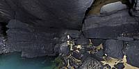
I drove 80 km from my home to the Notranjska Region on the evening of September 15th. We were a team of six spelunkers. The entrance into the cave and being there was high risk as the water could rise within a few minutes and passages were very tightâas an example one passage had over 50 m of crawling in about a 30 cm tall tunnel. I had taken the minimum of equipment, i.e., only a Canon 5DII with a Tokina 107, Precision Atom head, Velbone carbon fiber tripod and a 1000 ANSI lumen torch with wide beam for light-painting.It was a historical night for the exploration of the Äolnici-Obrh Cave. The cave is not a usual cave as it is a vent-hole and a spring of the Obrh brook which flows into the intermediate Lake CerkniÅ¡ko jezero. The entry into the cave was discovered in 2007 by the spelunking team of DLKJ, lead by Slovenian geographer Matej KržiÄ. At that time further exploration was not possible due to the nature of the cave which is in the epifreatic zone (maybe even phreatic zone), that means that the cave is below the water table and flooded. The low rainfall season dried the siphons and entry into the cave was possible trough the tight passages right to the dried subterranean riverbed.
Even after the heavy rain the following Sunday the cave was still had dry siphons so another expedition was organized on Saturday, September 24th. Another 11 hours of creeping trough the tight (epi) freatic zone and... surprise after few hours... filled siphon with the lake on the top. We swam across (and named the lake "Lake of Five Swimmers") and continued... to the cavern which was 150 m long and about 40-50 m high. The completely new subterranean world after tight passages! Beautiful stalactites, ponds and findings of the Ice Age bear skeletons...
The VR panorama shows the subterranean lake above the siphon at the currently final explored point of the cave. The man sitting on a stone is Matej KržiÄ, the finder of the cave.
Location
Lat: 45° 43' 15.34" N
Long: 14° 24' 59.27" E
Elevation: 550 m
Precision is: High. Pinpoints the exact spot.
Equipment
Canon EOS 5D MK2, Tokina 107 at 12mm fisheye shaved, Atom Precision panohead, Velbon Sherpa 640 carbon fiber tripod, Led Lenser X21 flashlight.
 Tap or click the zoom icon in the bottom right corner of the picture to switch between in-page and fullscreen view